Skip to product information
1 of 8

Garmin

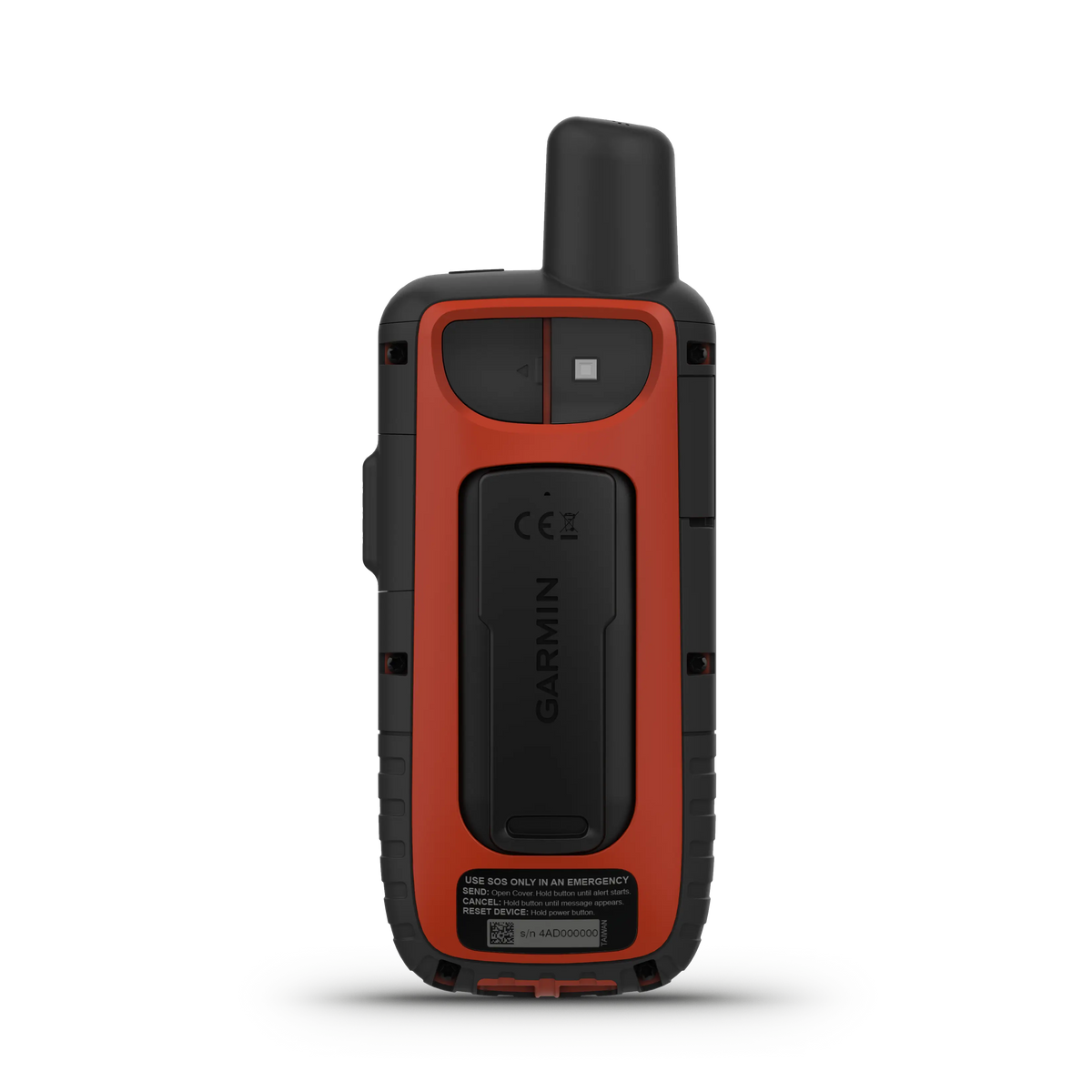
Garmin GPSMAP® 66i

Garmin GPSMAP® 66i

Regular price $599.00 USD
Regular price Sale price $599.00 USD
Sale Sold out
Shipping calculated at checkout.
Quantity

Low stock: 5 left

  • FAST SHIPPING
  • 30 DAY RETURNS
  • SECURE CHECKOUT

View full details

Product Description

This handheld is built to military standards for thermal, shock and water performance (MIL-STD-810), and it’s even compatible with night vision goggles. The GPSMAP 66 series helps you keep gear to a minimum with a built-in LED flashlight that can be used as a beacon to signal for help. Plan, review and sync waypoints, routes and tracks by using the Garmin Explore mobile app and website. You can even review completed activities while still in the field. Features: BATTERY LIFE Turn on Expedition mode, and get up to 200 hours of battery life while using inReach technology. In the default tracking mode, you get up to 35 hours of battery life, and your device will save your location every 10 minutes. MULTI-GNSS SUPPORT Access multiple global navigation satellite systems (GPS and GALILEO) to track in more challenging environments than GPS alone. ABC SENSORS Navigate every trail with ABC sensors, including an altimeter for elevation data, barometer to monitor weather and 3-axis electronic compass. BIRDSEYE SATELLITE IMAGERY Download high-resolution, photo-realistic maps directly to your device without an annual subscription. Easily find trails, pick stand locations, find parking, create waypoints and more. PRELOADED TOPO MAPS Preloaded TopoActive U.S. and Canada maps show you terrain contours, topographic elevations, summits, parks, coastlines, rivers, lakes and geographical points. WIKILOC TRAILS This preloaded app lets you easily download hiking, cycling and other Wikiloc trails shared by outdoor enthusiasts like you. Get a free 60-day Wikiloc Premium trial to try this and other exclusive features. Learn more. TWO-WAY MESSAGING Exchange text messages with loved ones, post to social media, or communicate from inReach to inReach in the field (satellite subscription required). INTERACTIVE SOS ALERTS In case of emergency, trigger an interactive SOS message to the Garmin IERCC, a 24/7 staffed professional emergency response coordination center (satellite subscription required). LOCATION SHARING Track your location, and share it with those at home or out in the field. They’ll be able to see your progress or ping your device for your GPS location and more (satellite subscription required). 100% GLOBAL IRIDIUM® SATELLITE NETWORK Instead of relying on cellphone coverage, now your messages, SOS alerts and tracking are transferred via the global Iridium satellite network (satellite subscription required). OPTIONAL INREACH WEATHER Use inReach connectivity to get detailed weather updates on GPSMAP 66i or a compatible device paired with the Garmin Explore™ app. Request weather forecasts for your current location, waypoints or destinations on your route. ACTIVE WEATHER When paired with your compatible smartphone, you can get real-time forecast information and live weather radar, so you’re always aware of the surrounding conditions. Specifications: Display Size 1.5"W x 2.5"H (3.8 x 6.3 cm); 3" diag (7.6 cm) Battery type rechargeable, internal lithium-ion Display resolution 240 x 400 pixels GPS Yes Dimension 2.5” x 6.4” x 1.4” (6.2 x 16.3 x 3.5 cm) Interface high speed micro USB and NMEA 0183 compatible Waterproof IPX7 Weight 8.1 oz (230 g) with batteries Display Type transflective color TFT Battery life up to 35 hours at 10-minute trackingUp to 200 hours at 30-minute tracking (power save mode) High-sensitivity receiver Yes Maps & Navigation External memory storage yes (32 GB max microSD™ card) Waypoints/favorites/locations 10000 Preloaded maps yes (TopoActive, routable) Basemap Yes Navigation Routes 250, 250 points per route; 50 points auto routing Navigation Track Log 20000 points, 250 saved gpx tracks, 300 saved fit activities Memory/History 16 GB (user space varies based on included mapping) Ability to add maps Yes Features Send route selection to MapShare during trip Yes BirdsEye yes (direct to device) Send waypoints to MapShare during trip Yes Active Weather  Yes Contacts No Rinex logging Yes inReach remote widget No Pairs with Garmin Connect™ Mobile Yes Touchscreen No LED beacon flashlight Yes inReach remote compatible Yes Sun and moon information Yes Virtual keyboard for custom messaging Yes MapShare compatible with tracking Yes Geocaching-friendly yes (Geocache Live) Send and receive text messages to other inReach device Yes GLONASS No Send and receive text messages to SMS and email Yes Frequency band No Displays national, state and local parks, forests, and wilderness areas Yes Smart notifications on handheld Yes Connect IQ™ (downloadable watch faces, data fields, widgets and apps) Yes Custom maps compatible yes (500 custom map tiles) Compatible with Earthmate No Connections Wireless Connectivity yes (Wi-Fi®, BLUETOOTH®, ANT+®) LiveTrack Yes Exchange locations with other inReach device Yes Vibration alert No Map segments 15000 Point-to-point navigation Yes Picture viewer Yes Barometric altimeter Yes Weather Yes XERO™ Locations Yes Interactive SOS Yes VOX (voice activation) No Automatic routing (turn by turn routing on roads) for outdoor activities Yes GPS compass (while moving) Yes Includes detailed hydrographic features (coastlines, lake/river shorelines, wetlands and perennial and seasonal streams) Yes Includes searchable points of interests (parks, campgrounds, scenic lookouts and picnic sites) Yes Hunt/fish calendar Yes Compass Yes (tilt-compensated 3-axis) Compatible with Garmin Explore™ app Yes Tracks 250 Galileo Yes Garmin Explore website compatible Yes Area calculation Yes MIL-STD-810 yes (thermal, shock, water) Location reporting (send and receive GPS positions) No VIRB® Remote Yes

This handheld is built to military standards for thermal, shock and water performance (MIL-STD-810), and it’s even compatible with night vision goggles. The GPSMAP 66 series helps you keep gear to a minimum with a built-in LED flashlight that can be used as a beacon to signal for help. Plan, review and sync waypoints, routes and tracks by using the Garmin Explore mobile app and website. You can even review completed activities while still in the field.

Features:

BATTERY LIFE

Turn on Expedition mode, and get up to 200 hours of battery life while using inReach technology. In the default tracking mode, you get up to 35 hours of battery life, and your device will save your location every 10 minutes.

MULTI-GNSS SUPPORT

Access multiple global navigation satellite systems (GPS and GALILEO) to track in more challenging environments than GPS alone.

ABC SENSORS

Navigate every trail with ABC sensors, including an altimeter for elevation data, barometer to monitor weather and 3-axis electronic compass.

BIRDSEYE SATELLITE IMAGERY

Download high-resolution, photo-realistic maps directly to your device without an annual subscription. Easily find trails, pick stand locations, find parking, create waypoints and more.

PRELOADED TOPO MAPS

Preloaded TopoActive U.S. and Canada maps show you terrain contours, topographic elevations, summits, parks, coastlines, rivers, lakes and geographical points.

WIKILOC TRAILS

This preloaded app lets you easily download hiking, cycling and other Wikiloc trails shared by outdoor enthusiasts like you. Get a free 60-day Wikiloc Premium trial to try this and other exclusive features. Learn more.

TWO-WAY MESSAGING

Exchange text messages with loved ones, post to social media, or communicate from inReach to inReach in the field (satellite subscription required).

INTERACTIVE SOS ALERTS

In case of emergency, trigger an interactive SOS message to the Garmin IERCC, a 24/7 staffed professional emergency response coordination center (satellite subscription required).

LOCATION SHARING

Track your location, and share it with those at home or out in the field. They’ll be able to see your progress or ping your device for your GPS location and more (satellite subscription required).

100% GLOBAL IRIDIUM® SATELLITE NETWORK

Instead of relying on cellphone coverage, now your messages, SOS alerts and tracking are transferred via the global Iridium satellite network (satellite subscription required).

OPTIONAL INREACH WEATHER

Use inReach connectivity to get detailed weather updates on GPSMAP 66i or a compatible device paired with the Garmin Explore™ app. Request weather forecasts for your current location, waypoints or destinations on your route.

ACTIVE WEATHER

When paired with your compatible smartphone, you can get real-time forecast information and live weather radar, so you’re always aware of the surrounding conditions.


Specifications:

Display Size 1.5"W x 2.5"H (3.8 x 6.3 cm); 3" diag (7.6 cm)
Battery type rechargeable, internal lithium-ion
Display resolution 240 x 400 pixels
GPS Yes
Dimension 2.5” x 6.4” x 1.4” (6.2 x 16.3 x 3.5 cm)
Interface high speed micro USB and NMEA 0183 compatible
Waterproof IPX7
Weight

8.1 oz (230 g) with batteries

Display Type transflective color TFT
Battery life

up to 35 hours at 10-minute tracking
Up to 200 hours at 30-minute tracking (power save mode)

High-sensitivity receiver Yes

Maps & Navigation

External memory storage yes (32 GB max microSD™ card)
Waypoints/favorites/locations 10000
Preloaded maps

yes (TopoActive, routable)

Basemap Yes
Navigation Routes 250, 250 points per route; 50 points auto routing
Navigation Track Log 20000 points, 250 saved gpx tracks, 300 saved fit activities
Memory/History 16 GB (user space varies based on included mapping)
Ability to add maps Yes

Features

Send route selection to MapShare during trip Yes
BirdsEye yes (direct to device)
Send waypoints to MapShare during trip Yes
Active Weather  Yes
Contacts No
Rinex logging Yes
inReach remote widget No
Pairs with Garmin Connect™ Mobile Yes
Touchscreen No
LED beacon flashlight Yes
inReach remote compatible Yes
Sun and moon information Yes
Virtual keyboard for custom messaging Yes
MapShare compatible with tracking Yes
Geocaching-friendly yes (Geocache Live)
Send and receive text messages to other inReach device Yes
GLONASS No
Send and receive text messages to SMS and email Yes
Frequency band No
Displays national, state and local parks, forests, and wilderness areas Yes
Smart notifications on handheld Yes
Connect IQ™ (downloadable watch faces, data fields, widgets and apps) Yes
Custom maps compatible yes (500 custom map tiles)
Compatible with Earthmate No
Connections Wireless Connectivity

yes (Wi-Fi®, BLUETOOTH®, ANT+®)

LiveTrack Yes
Exchange locations with other inReach device Yes
Vibration alert No
Map segments 15000
Point-to-point navigation Yes
Picture viewer Yes
Barometric altimeter Yes
Weather Yes
XERO™ Locations Yes
Interactive SOS Yes
VOX (voice activation) No
Automatic routing (turn by turn routing on roads) for outdoor activities Yes
GPS compass (while moving) Yes
Includes detailed hydrographic features (coastlines, lake/river shorelines, wetlands and perennial and seasonal streams) Yes
Includes searchable points of interests (parks, campgrounds, scenic lookouts and picnic sites) Yes
Hunt/fish calendar Yes
Compass Yes (tilt-compensated 3-axis)
Compatible with Garmin Explore™ app Yes
Tracks 250
Galileo Yes
Garmin Explore website compatible Yes
Area calculation Yes
MIL-STD-810 yes (thermal, shock, water)
Location reporting (send and receive GPS positions) No
VIRB® Remote Yes


Features
BATTERY LIFE Turn on Expedition mode, and get up to 200 hours of battery life while using inReach technology. In the default tracking mode, you get up to 35 hours of battery life, and your device will save your location every 10 minutes. MULTI-GNSS SUPPORT Access multiple global navigation satellite systems (GPS and GALILEO) to track in more challenging environments than GPS alone. ABC SENSORS Navigate every trail with ABC sensors, including an altimeter for elevation data, barometer to monitor weather and 3-axis electronic compass. BIRDSEYE SATELLITE IMAGERY Download high-resolution, photo-realisticmapsdirectly to your device without an annual subscription. Easily find trails, pick stand locations, find parking, create waypoints and more. PRELOADED TOPO MAPS PreloadedTopoActiveU.S. and Canada maps show you terrain contours, topographic elevations, summits, parks, coastlines, rivers, lakes and geographical points. WIKILOC TRAILS Thispreloaded applets you easily download hiking, cycling and other Wikiloc trails shared by outdoor enthusiasts like you. Get a free 60-dayWikiloc Premiumtrial to try this and other exclusive Features:.Learn more. TWO-WAY MESSAGING Exchange text messages with loved ones, post to social media, or communicate from inReach to inReach in the field (satellite subscription required). INTERACTIVE SOS ALERTS In case of emergency, trigger an interactive SOS message to the Garmin IERCC, a 24/7 staffed professional emergency response coordination center (satellite subscription required). LOCATION SHARING Track your location, and share it with those at home or out in the field. They’ll be able to see your progress or ping your device for your GPS location and more (satellite subscription required). 100% GLOBAL IRIDIUM® SATELLITE NETWORK Instead of relying on cellphone coverage, now your messages, SOS alerts and tracking are transferred via the global Iridium satellite network (satellite subscription required). OPTIONAL INREACH WEATHER Use inReach connectivity to get detailed weather updates on GPSMAP 66i or a compatible device paired with theGarmin Explore™ app. Request weather forecasts for your current location, waypoints or destinations on your route. ACTIVE WEATHER When paired with yourcompatible smartphone, you can get real-time forecast Detailsrmation and live weather radar, so you’re always aware of the surrounding conditions.
Specifications
Display Size: 1.5"W x 2.5"H (3.8 x 6.3 cm); 3" diag (7.6 cm) Battery type: rechargeable, internal lithium-ion Display resolution: 240 x 400 pixels GPS: Yes Dimension: 2.5” x 6.4” x 1.4” (6.2 x 16.3 x 3.5 cm) Interface: high speed micro USB and NMEA 0183 compatible Waterproof: IPX7 Weight: 8.1oz (230 g) with batteries Display Type: transflective color TFT Battery life up to 35 hours at 10-minute tracking Up to 200 hours at 30-minute tracking (power save mode) High-sensitivity receiver: Yes Maps & Navigation External memory storage: yes (32 GB max microSD™ card) Waypoints/favorites/locations: 10000 Preloaded maps: yes (TopoActive, routable) Basemap: Yes Navigation Routes: 250, 250 points per route; 50 points auto routing Navigation Track Log: 20000 points, 250 saved gpx tracks, 300 saved fit activities Memory/History: 16 GB (user space varies based on Contents mapping) Ability to add maps: Yes Features: Send route selection to MapShare during trip: Yes BirdsEye: yes (direct to device) Send waypoints to MapShare during trip: Yes Active Weather: Yes Contacts: No Rinex logging: Yes inReach remote widget: No Pairs with Garmin Connect™ Mobile: Yes Touchscreen: No LED beacon flashlight: Yes inReach remote compatible: Yes Sun and moon Detailsrmation: Yes Virtual keyboard for custom messaging: Yes MapShare compatible with tracking: Yes Geocaching-friendly: yes (Geocache Live) Send and receive text messages to other inReach device: Yes GLONASS: No Send and receive text messages to SMS and email: Yes Frequency band: No Displays national, state and local parks, forests, and wilderness areas: Yes Smart notifications on handheld: Yes Connect IQ™ (downloadable watch faces, data fields, widgets and apps): Yes Custom maps compatible: yes (500 custom map tiles) Compatible with Earthmate: No Connections Wireless Connectivity: yes (Wi-Fi®, BLUETOOTH®, ANT+®) LiveTrack: Yes Exchange locations with other inReach device: Yes Vibration alert: No Map segments: 15000 Point-to-point navigation: Yes Picture viewer: Yes Barometric altimeter: Yes Weather: Yes XERO™ Locations: Yes Interactive SOS: Yes VOX (voice activation): No Automatic routing (turn by turn routing on roads) for outdoor activities: Yes GPS compass (while moving): Yes Includes detailed hydrographic Features: (coastlines, lake/river shorelines, wetlands and perennial and seasonal streams): Yes Includes searchable points of interests (parks, campgrounds, scenic lookouts and picnic sites): Yes Hunt/fish calendar: Yes Compass: Yes (tilt-compensated 3-axis) Compatible with Garmin Explore™ app::Yes Tracks: 250 Galileo: Yes Garmin Explore website compatible: Yes Area calculation: Yes MIL-STD-810: yes (thermal, shock, water) Location reporting (send and receive GPS positions): No VIRB® Remote: Yes
30 DAY RETURNS
FAMILY-OWNED IN THE PNW
FAST SHIPPING
REAL PEOPLE, REAL SUPPORT
SECURE CHECKOUT
1 of 3